
The St. Lawrence River has shaped Quebec in many ways, historically, culturally and economically. Used as a primary route by the first European explorers during the New France era, it remains Canada’s most important navigable and commercial waterway. A true backbone of the territory, the St. Lawrence is also one of the most emblematic symbols of the Quebec landscape, renowned for its natural beauty and ecological richness.
Much more than a river, the St. Lawrence is first and foremost a vast gulf stretching from the Magdalen Islands to Pointe‑des‑Monts on the North Shore. It then transforms into an estuary, before becoming a river at Lac Saint‑Pierre, an area recognized for its exceptional biodiversity. This unique transition between marine and freshwater environments makes the St. Lawrence an ecosystem of significant scientific and tourism value.
Characteristics of the River
The St. Lawrence River originates in Lake Ontario and flows northeast, passing through iconic cities such as Montreal and Quebec City, before emptying into the Gulf of St. Lawrence. Although it seems to have been part of Quebec’s landscape forever, the St. Lawrence is geologically young. Its riverbed corresponds to a deep fracture in the Earth’s crust, revealed approximately 10,000 years ago following the retreat of the glaciers from the Champlain Sea and the Goldthwait Sea.
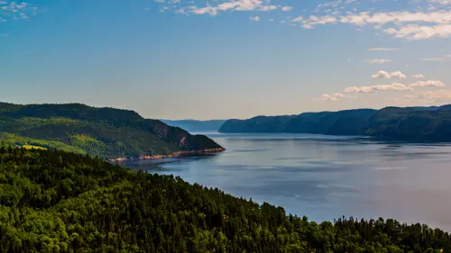
Together with the Great Lakes, the St. Lawrence forms a vast hydrographic network stretching more than 3,058 kilometres deep into North America. Choosing a cruise on the St. Lawrence River offers a unique perspective from which to observe this majestic waterway.
Marine Life Observation on the St. Lawrence
The maritime Quebec regions are among the best places in the world for whale watching. The Saguenay–St. Lawrence Marine Park is a must‑see location for observing marine mammals of the St. Lawrence. Covering an area of 1,245 square kilometres, this protected area provides an ideal habitat thanks to its high concentration of food. The interaction of tides within the Laurentian Channel creates an exceptional feeding ground, attracting numerous whale species year after year.
Aboard the Croisières AML fleet, it is possible to spot up to 13 species of marine mammals, including the fin whale, the minke whale and the beluga. These excursions offer a unique opportunity to observe whales in their natural environment, while respecting their ecosystem.
An Emblem of the St. Lawrence River
More than 40 lighthouses line the shores of the St. Lawrence River, standing as silent witnesses to Quebec’s maritime history. For many years, their primary role was to ensure the safety of navigators in often challenging conditions. Today, these lighthouses have become true guardians of fluvial heritage.
In Tadoussac, one of the most recognizable landmarks is the lighthouse located at the meeting point of the St. Lawrence River and the Saguenay Fjord. Its official name is the Haut-Fond Prince Lighthouse, although locals affectionately call it “La Toupie” (the spinning top). Part of the landscape since 1905, this iconic lighthouse rises in the middle of the river at the mouth of the fjord. Standing 25.3 metres high, the current tower has been in service since 1964 and bears witness to a rich maritime history.
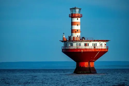
The name Haut-Fond Prince refers to the shoal on which the lighthouse was built, an area considered one of the most hazardous sections of the St. Lawrence River. Its design had to withstand intense ice pressure, particularly in this location where the river reaches a width of approximately 23 kilometres, allowing large ice movements. Its nickname, “La Toupie,” comes from its distinctive structure, featuring a conical base supporting a cylindrical tower, easily recognizable by its red and white horizontal bands.
A Storm that Marked the History of Tadoussac
From the very first year after its construction, the lighthouse left a strong impression on the residents of Tadoussac. During its first winter, a violent storm swept across the river, striking the area where the lighthouse stood with full force.
As the rising tide threatened to sweep everything away, the structure was put to a severe test. The doors began to give way and waves gradually flooded the interior. The three keepers were forced to take refuge in the generator room and send out a distress call.
Due to the extreme conditions, no vessel was able to come to their aid. Convinced that the night would be their last, they eventually saw the tide recede and the winds subside. By morning, they discovered the extent of the damage, as the village had been devastated by the storm. The keepers were ultimately evacuated by helicopter, safe but deeply affected by the ordeal.
Today, the lighthouse remains a powerful symbol for the residents of Tadoussac. During whale watching cruises on the St. Lawrence River, captains often pass close to “La Toupie,” offering passengers a rare opportunity to admire this iconic landmark up close.
Experiences for Every Taste
Departing from the Tadoussac wharf, several types of excursions are available to experience whale watching on the St. Lawrence River, depending on your preferences. By choosing a whale watching boat tour, you will board the AML Grand Fleuve for an adventure lasting approximately three hours. This option offers exceptional panoramic views, along with a comfortable vessel featuring indoor and outdoor viewing areas specifically designed for observing marine mammals.
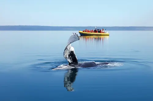
If you are seeking adventure and want to be at the heart of the action, the Zodiac experience is for you. Closer to the water, this excursion offers a more sporty and immersive approach. Regardless of the option chosen, each outing is accompanied by a certified naturalist or a captain‑naturalist, who shares insights about whales, the different species, their behaviour and their natural habitat.
Whether through its historical role, its ecological richness or the experiences it offers, the St. Lawrence River remains a territory to be discovered. There is no better way to explore its many facets than by taking an excursion on its waters and observing it from a unique perspective.


